360° 3D LiDAR Laser Scanning
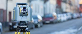
A 3D model world calls for exceptional tools when it comes to building and maintaining infrastructures. Scanning with a 3D Total Data Collection Station with high-density enhanced 3D scanning including high-accuracy 3D total station measurements is a civil trifecta. SUE creates a point cloud with millions of points. The point cloud is, in essence, a three-dimensional rendering that resembles a photo. The Robotic Total Station, which allows us to collect data conventionally. This allows us to complete a project of this nature with one piece of equipment and therefore saves our patrons money.

SUE’s type of 3D Scanning combines surveying, imaging, and scanning into one data instrument, and helped collect data points of the layers and varying textures. We’re confident we can provide the highest quality of surveying services to all of our projects, no matter the type, and we’re able to do that with current technology and software.
Call to schedule a lidar laser scan in Honolulu +1-808-284-2538